← Back
Discover MAS: Smart Data Fusion for Comprehensive Maritime Understanding

This includes instantaneous analysis, historical monitoring of specific areas or fleets, and alert on events or behaviors. Integrated real-time maritime awareness is revolutionizing ocean surveillance, MAS provides actionable intelligence to combat illegal activities at sea, wherever they occur thanks to real-time monitoring and surveillance, easy access to high resolution satellite imagery and geospatial intelligence.
CLS’ Maritime Awareness System: a unique state-of-the-art platform for maritime intelligence
With MAS, maritime stakeholders can:
- Enhance maritime security and reduce illegal activities
- Improve operational efficiency and decision-making process
- Comply with international regulations and standards
- Implement a cost-effective monitoring solution and reduce operational risks.
Our analyses offer authorities insights into vessel behavior as part of a comprehensive risk assessment process, enabling the monitoring of sea zones and the efficient allocation of enforcement resources.
Policing the Seas: A New Era of Maritime Surveillance
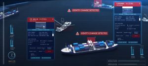
 Imagine this scenario: You receive an AIS alert of two ships in close proximity. One is unregistered according to the LRIT, but you need to confirm this through another system on a different computer.
The ships are moving fast, and you must quickly decide whether to dispatch the Coast Guard. If you act too hastily, you might incur huge costs for what could turn out to be a legal activity. Yet, if you delay, you risk missing the chance to halt illegal operations.
What do you do? This is a common challenge maritime authorities face worldwide.
Big Data Analytics and Artificial Intelligence: The Future of Maritime Security
With the advent of big data analytics and artificial intelligence, maritime security is undergoing a transformation. Data fusion enables the handling of massive amounts of heterogeneous information, allowing for new types of analysis that were previously impossible. To accurately detect illegal activity, multiple data sources must be corroborated. Different technologies have their own strengths and weaknesses, and combining satellite AIS, radar, and optical data provides a comprehensive view.
For instance, one client relying solely on radar lost track of a suspected transshipment when the boat went out of range. This highlighted the necessity for an integrated platform that consolidates all data types in one place.
Can Too Much Data Be a Bad Thing?
However, an overload of raw, undigested data can be counterproductive. Decision makers need to make swift decisions based on data that is already fused, presented in an easily interpretable format. A user-friendly interface that allows for quick differentiation between regular and illegal activities in real-time is crucial.
With MAS, you gain complete global coverage: Detecting and Tracking suspect ships anywhere
Identifying a suspect ship is just the beginning. The ability to follow that vessel anywhere in the world, under any weather or ocean conditions, is essential. If the ship goes off radar or terrestrial AIS, intervention becomes challenging. Comprehensive coverage from space, utilizing high-performance satellite technology, is vital.

With MAS, monitor what is happening at sea.
CLS has developed the Maritime Awareness System (MAS) to make this advanced technology accessible to authorities and now to any kind of maritime industry, private or public. With MAS, you can detect illegal activities, receive automatic alerts, and view all necessary information on a single screen.
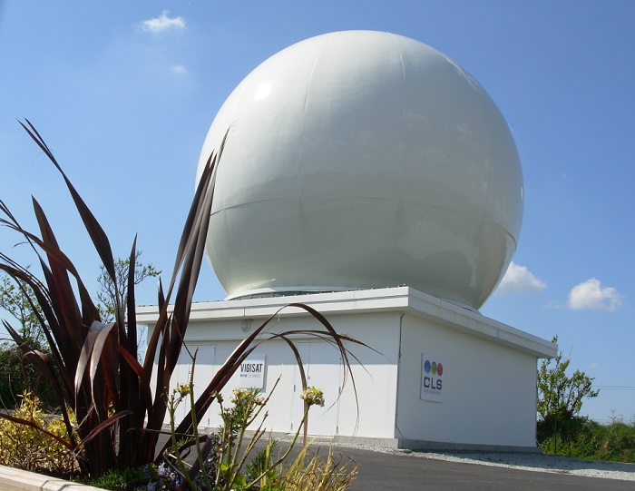
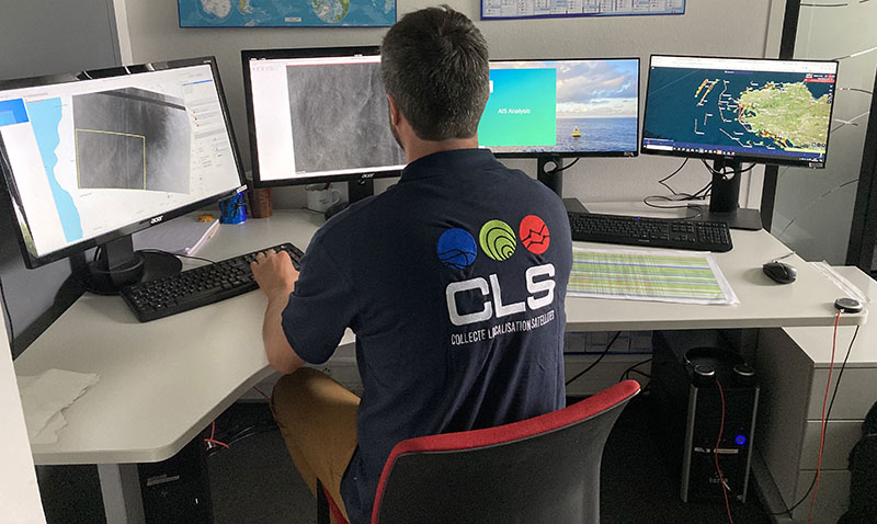
Brest, (France) VIGISAT direct receiving, processing and analysis station
MAS Backstage: The Unsung and 24/7 Work of Maritime Guardians
At the heart of MAS, CLS VIGISAT is a key network of stations dedicated to receiving, processing, and analyzing high-resolution SAR and optical images.
VIGISAT consists of an operational center and terrestrial image reception antennas dedicated to the exploitation of Earth observation data and maritime intelligence.
VIGISAT a network of strategic stations
The VIGISAT network is made up of 3 image-receiving ground stations, based in Brest, Toulouse and Greece, and can be extended to include third-party stations. They enable direct reception and processing of radar satellite images from TerraSAR-X/Tandem-X/Paz, Radarsat-2 and Sentinel-1-A&B sensors.
A 24/7 intelligence and analysis center with 3 pillars
VIGISAT 24/7 operations center
- A processing chain dedicated to the reception, processing and analysis of satellite radar (SAR) and optical imagery, and to real-time satellite RF detection.
- A team of analysts and photo-interpreters with expertise in maritime intelligence, some of them with over 20 years’ experience in intelligence centers in various armies.
- An internationally recognized team of technical experts, dedicated to R&D activities on data processing and analysis.
CLS hosts and operates the Mission Performance Cluster (SAR-MPC) at its Brest site, which is responsible for the performance of the Sentinel-1 mission, part of the central ground segment of the European Copernicus program.
Besides, VIGISAT has a multi-mission capability for the collection and processing of radar and optical satellite images, and for satellite RF detections from a wide network of constellations (Unseenlabs, Iceye, Maxar, Deimos, etc.).
In addition to satellite imagery, VIGISAT also collects several sources of information for maritime intelligence: ship positions (VMS, AIS, LRIT), OSINT data, meteorological or oceanographic data.
Embracing the Future: Integrating New Space Partnerships
 As we venture further into the 21st century, the space industry is experiencing a renaissance fueled by unprecedented technological advancements, private sector involvement, and international collaboration. This new era of space exploration and commercialization, often termed “New Space,” is reshaping our understanding of the cosmos and its potential benefits for humanity.
As part of certain operations or updates from our partners, we are in constant reevaluation of market players and technologies to ensure our solutions and services remain cutting-edge. We are actively expanding our partnerships, particularly towards players in the New Space sector.
Shipowner? Insurer? Maritime Safety and Surveillance Organization? Discover How Our New VIGISAT Services Can Enhance Your Operations
We have developed new services, utilizing the 24/7 expertise of CLS’ VIGISAT analysis team, to support maritime stakeholders, both public and private, by gathering evidence and confirming suspicions.
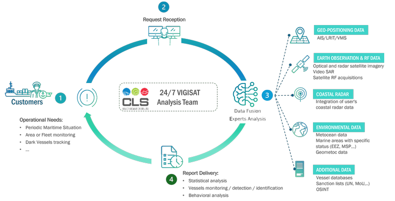
Working principle for Vigisat added-value services to support operation
Upon request, we conduct thorough investigations, analyzing and processing multi-source data with CLS’ expertise. If needed, we commission additional information to deliver a comprehensive and reliable analysis of the maritime situation.
Our detailed, easy-to-interpret reports enable direct application of insights, including statistical analysis, vessel monitoring, detection, identification, and behavioral analysis.
Delivering the Best Data Solutions for All Maritime Stakeholders, Both Public and Private
Whatever you may need in terms of maritime or fleet surveillance, we are here to support you. Here are some examples of issues we can solve and assist you with; this list is far from exhaustive:
- Analysis of a Maritime Area,
- Monitoring of activities in a specific area of interest,
- Maritime situation,
- Vessel follow-up,
- Fleet follow-up,
- Dark vessel detection and identification,
- Detection of IUU fishing activities
- Pollution detection,
- Reconstruction of incidents and abnormal behavior at sea.
- And more, tell us your needs, we have the solution.
Related Posts: