← Back
High Seas Treaty: UN Makes Historic Deal to Protect International Waters

“The ship has reached the shore,” conference chair Rena Lee announced at UN headquarters in New York shortly before 9:30 p.m. on Saturday, March 5, to a round of applause from delegates.
The first international treaty to address threats to ecosystems crucial to humanity, the agreement is widely hailed as a milestone in biodiversity protection. After more than 15 years of discussions, including four years of formal negotiations, it is after two weeks of intense debates, including a marathon session on Friday night, that delegates finalized a text that can no longer be significantly modified.
Tackling the Destructive Trends that Threaten the Health of the Oceans
The high seas begin where the exclusive economic zones (EEZs) of states end, at a maximum of 200 nautical miles (370 km) from the coast, and are therefore not under the jurisdiction of any state. Even if it represents more than 60% of the oceans and nearly half of the planet, it has long been ignored in the environmental fight, in favor of coastal areas or a few emblematic species. It also provides half of the oxygen we breathe and limits global warming by absorbing a significant part of the CO2 emitted by human activities.
But the oceans are weakening, victims of these emissions (warming, acidification of water …), pollution of all kinds, overfishing or illegal fishing.
However, the ocean is central, more than a billion people depend on fish as a main source of protein, a reasoned management of fishing is therefore essential. The interest of this historic treaty is to fill the gaps of the previous one and give a new framework to the international community to manage this common space. Considering the geopolitical context, it is a form of achievement to have succeeded in setting new rules for a common, sustainable and equitable management of a space that the international community shares.
Preserving Marine Life and Biodiversity from Space
How can we ensure that the marine areas to be created in international waters are effectively protected and monitored?
To act effectively, particularly to safeguard ecosystems in the high seas, requires continuous monitoring. We will have to find the means and the conditions so that everything that has been adopted can be put in place.
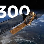
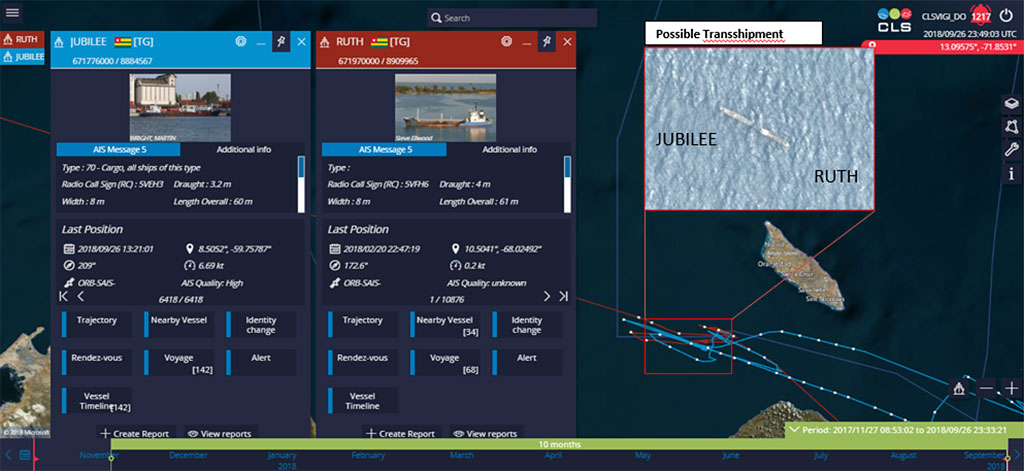
This is where satellite monitoring comes in. Watching over the vastness of the oceans from space, day and night, 24 hours a day, nothing escapes the watchful eye of the nearly 400 satellites used by CLS. The expertise of our analysts does the rest. More than 20,000 images are scanned and analyzed each year by these satellite imaging specialists.
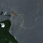
Thanks to their accurate interpretation, the images speak for themselves: there is pollution, there are boats fishing illegally, there is a cargo ship in distress, there is another illegal traffic or smuggling act.
Space-Based Data at the Service of the High Seas
More and more data are available in the maritime domain, making it possible to monitor large and remote areas. But without the proper tools to extract the information that matters, sheer quantities of data are overwhelming – and unusable.
This profusion of data makes it possible to monitor territories that were previously isolated and to track ships of interest across the oceans. The very essence of maritime intelligence, this mass of data can nevertheless be unusable without the appropriate tools. In response to this challenge, and in order to help protect the oceans, CLS has taken the latest technologies and created the MAS solution, an exclusive tool based on the needs expressed by maritime authorities, placing data at the heart of operational theaters.
Empowerment: Big Data, AI and Machine Learning
MAS (Maritime Awareness System) exploits and processes Big Data allowing you to receive, store and query, in real-time huge volumes of multiple data sources (AIS, SAT-AIS, LRIT, VMS, SAR, optical imagery and vessel information).
These multiple data sets form the basis for performing real-time or historic surveillance on an area, fleet or vessel of interest, as well as creating alerts for specific events or vessel behavior.
Based on 30 years’ experience working with the maritime industry, CLS developed algorithms to perform automated detection of vessel behavior and ensuring integrity and quality of data.
MAS Platform
Limiting Overfishing, Fighting Illegal Fishing, Detecting and Combatting Pollutions, in the High Seas
By harnessing cutting edge satellite imagery and sensor data with in-depth analysis to provide an unparalleled maritime picture, MAS is a trusted and proven solution helping maritime agencies to access and understand mission relevant information enabling time critical decision making with an unquestioned level of security.
Whether it’s identifying polluters, whether accidental or intentional, tracking the drift of oil slicks and supporting the implementation of response resources to contain the pollution and limit the damage, MAS is positioned as the reference tool already used by many of the world’s leading maritime nations. And since the satellite knows no limits, the high seas are naturally also in its sights.
In the same way, illegal fishing is also a scourge to fight. It contributes to the overexploitation of the oceans, to the destruction of ecosystems and threatens the food security of millions of people. It also contributes to the problem of overfishing since those who practice it do not respect the rules, without consideration for the environment or the fishing quotas in regulated areas. On the high seas, where no rules applied until now, it is even worse, the law of the strongest prevails.
Here again, MAS is the very tool to detect this illegal activity and identify fraudulent vessels wherever they are.
CLS, at the Heart of Environmental Concerns
Currently only about 1% of the high seas are subject to conservation measures, and this emblematic agreement is considered essential if we hope to protect 30% of the world’s land and oceans by 2030, as all the world’s governments committed to do in December 2022.